

How to find us
Aston Tirrold URC and the Centre for Reflection are in the village of Aston Tirrold, which with the twin village of Aston Upthorpe, is on the spring line to the N of the Berkshire Downs in Oxfordshire. It is approximately half an hour's drive from Reading, Oxford, Wantage and Henley and is 4 miles SE of Didcot, 4 miles SW of Wallingford and less than a mile N off the A417 between the villages of Blewbury and Streatley.Postal address
Aston Tirrold United Reformed Church
Spring Lane, Aston Tirrold, Didcot, Oxon OX11 9EJ
tel: 01235 850423
By rail
Didcot Station, about 4 miles away, has frequent, direct rail services from London, Reading, Bristol, Birmingham and Oxford. It is also served from Birmingham, Southampton and Winchester, a change of train usually being necessary. You will then need a lift or a taxi to reach Aston Tirrold.
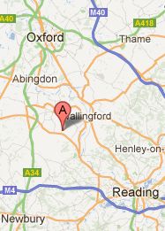
Map
The map shows the location of church and centre which are a short distance N of the A417 in the village of Aston Tirrold. The plus (+) and minus (-) symbols on the map allow you to choose to see a smaller or larger area.
Of the two roads leading N off the A417 to Aston Tirrold, take the westmost of the two for a more direct route to the church. This is marked as Spring Lane on the map. Having turned onto this lane and passed the first buildings on the right, you will negotiate a sharp, narrow, right angle, right hand bend. Once past this bend, you will see the church and its car park on the right of the next sharp, narrow, left hand, right angle bend.
See here a map that is larger on the screen and that shows you the scale.